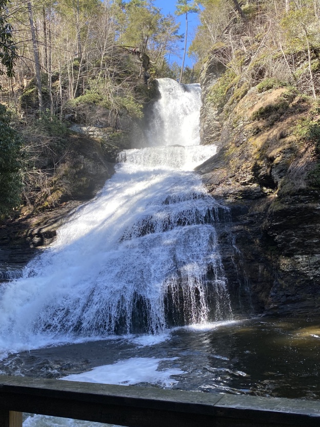
Category Archives: ink and watercolor

Dingmans Falls

Dingmans Falls

Dingmans Falls

Dingmans Falls

As I get more and more settled in, and as the weather improves, I’m looking for local hikes that aren’t too long or too difficult.  Dingmans Falls fit that description – a short 1.4 mile out-and-back trail if you leave from the center, which is not yet open for the season, so it becomes about 3.6 miles total from the parking area. The road to the center is paved, and the trail to the falls is mostly a wood walkway, handicap accessible.

Dingmans Falls Center

Dingmans Falls Center

At the falls, you can climb the steep wooden steps to the top of the falls, the second largest falls in Pennsylvania. (I did not go to the very top this time!)

I returned a few days later to sit and sketch Silver Thread Falls, located along the trail to Dingmans Falls. They are just lovely, like a narrow ribbon of flowing water, punctuated by the fallen trees across it.  I thought they were deserving of a sketch, although not too pleased with the result, here it is.
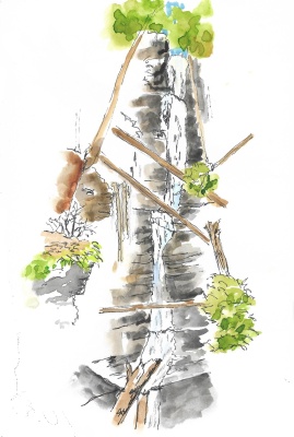
Silver Thread Falls

Silver Thread Falls

Grey Towers mansion

Grey Towers

Getting to know a new area can be daunting.  Where do you start? First, I got my driver license, next got my car registered, and then started to explore local hikes.  In March, my first trail was at Raymondskill, tried the Cliff trail and saw the falls. (That was where I found the gnarly tree in my last post!)

As I meet and chat with locals, I’ll ask, “where do you suggest I go to hike and where can I find local art?”   They recommended Grey Towers, a historic site that was once the summer estate of the Pinchot family.  This became my second hike, although I’d call it more of a walk.  It has interesting architecture, with a long, steep paved drive to get up to the house and grounds.  There are a variety of tours available (after it opens in May) of the buildings, forest trees and cemetery.

Only the crocus were out the day I went:

Grey Towers mansion

Grey Towers mansion and crocus

The Bait Box was built in the 1920s as a playhouse.  Loved the setting, so I sat and sketched, while visiting children ran about. The Bait Box at Grey Towers

Gnarly tree

Moved in – an update

Moving to a completely new area and a home with half the closet space can take up a lot of mental (and physical!) energy.  It’s now one month since moving in, and I am truly enjoying the space and views.  I’ve even found a local hike to get me outside, at least when it’s not a blizzard or freezing out.  The nearby Cliff Trail is easy and scenic.  Here’s a gnarly tree overlooking the Delaware River, sketched from my photo. Gnarly tree
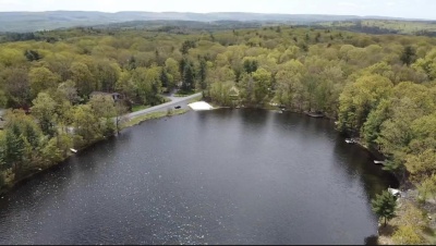
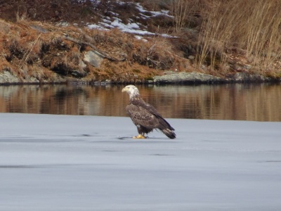
The view of the lake brings a calm mind, then excitement, when you realize a bald Eagle is within camera view!  Here’s a few snapshots grabbed before he took off…. Juvenile bald eagle 
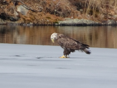
Hope you’re enjoying my new home adventures and discoveries!

2022 – it’s time for a new adventure!

It’s been a while since you’ve heard from me, I know, but with good reason – it is time for me to move to a new location.  Between the search, the paperwork, the prep before actually moving, AND a new grandbaby, it’s been quite busy, as you can imagine.  I really wanted to have fun sketching the new views but free time has been scarce.  So here is the view from my little lake house in NE PA:

And here is an aerial view of my house with the nearby beach:

All this excitement has not left time for sketching, but hoping to change that very soon! Meanwhile, my 2022 calendar consists of sketches from 2021.

Shrooms and berries

Back to local travel

Back home, I decided to try a trail that was new to me.  Monkey Run loop near Ithaca, NY.  A really nice walk in the woods, it was quite muddy in places, and no one else out, but surprise, surprise, lots of mosquitoes!  Apparently my bug juice wore off, and they (skeeters) really began to feast on me.  I was close to the end, so I picked up my pace, annnd missed a turn that would’ve taken me back a bit sooner.  It was supposed to be closer to 3 miles, but it ended up 4, but the good thing was it only took me 2 hours.  I’m definitely not a speed hiker, but the bites gave me some incentive to hurry! Fall Creek, Ithaca, NY

Not much for views, the best part followed Fall Creek, so my eyes were drawn (hehe) to what was on the ground, lots of fungi and berries.  Sketched at home AFTER I was safe from the skeeters.Shrooms and berries

View of Mt. Hood from top

The Northwest – Sleeping Beauty Mountain trail

After a worrisome day, waking up with severe vertigo, I nearly cancelled this trip.  Wasn’t sure how I could get on a plane with it.  Fortunately, it mostly cleared up, so the trip was on!  Still with traces of vertigo, flights and travel went smoothly, and we got to relax my first afternoon in Hood River.  Love Hood River, great vibes, and great people.

Sunset at the Columbia River

Nearly sunset at the Columbia River

We agreed to do the most difficult, but most “worth it” hike first. So day 2, we drove (I say we, but my friend did all the driving.). Got to give her credit for hosting, driving and being a great friend.  So we drove across the Columbia River to Washington, then up some back roads, which turned to dirt roads, with some edgy curves.  Took us about an hour to get to the trailhead, and there was only one other car there, which was great. “Only” a little over 2 miles in, but with 1,365’ gain.  And 6,000’ elevation. I’m not used to that at all, add the fact that it got a little scary towards the top with some vertigo kicking in.  Some of the last steep part was on my hands and knees, I didn’t trust standing up.
But, I must say, it was definitely WORTH IT! Proud of us both, and views of four separate mountains from the top.  Basically, we climbed a small mountain to get a better view of the big ones. 🙂

So relieved to have a chance to sit, I did several sketches from up here.  Added color back at home.

View of Mt. Adams from the trail

View of Mt. Adams, shortly before reaching the top

View of Mt. Hood from top

View of Mt. Hood from top

Another view of Mt. Adams from the top

Another view of Mt. Adams from the top. The clouds were starting to cover the top.

After all that work, we stopped at Mt. Hood winery (of course!) and I did a quick sketch while we relaxed.

View of Mt. Hood from Mt. Hood winery

View of Mt. Hood from Mt. Hood winery

I guess I’ll have to return, this place has so many amazing views, wine and delicious food!

Map Oregon & Washington

Headed west (northwest, that is)

Time to “just go” again!  International travel is not a sure thing, so I’ll stick to the USA instead. The northwest scenery – mountains, woods, and waterfalls just look amazing.   I am trying to choose this lighter pack that folds to pocket size, but may end up with my usual one. Here’s a “selfie” and a quick map.
Looking forward to catching up with a dear friend, hiking, dining and wine! Hope to share some gorgeous views and sketches.

New Outlander day pack

   New Outlander day pack

Map Oregon & Washington  Selfie art by bernadette